

Title: Israel, Gaza, West Bank
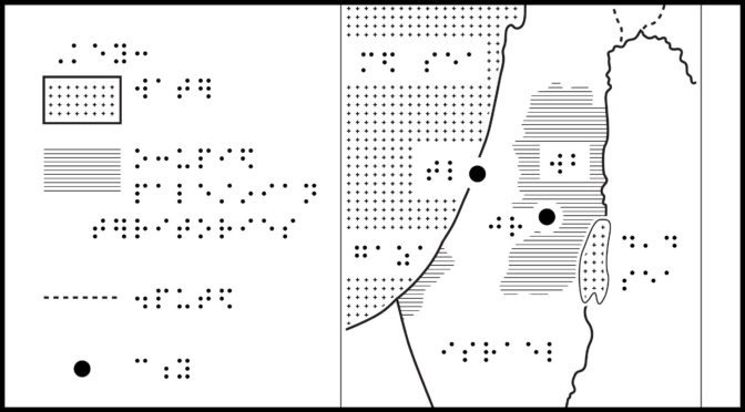
Description: Map of Israel-Palestine, Gaza Strip, West Bank, Golan, and neighboring countries. The map includes a north arrow and scale, approximately 1 inch = 40 miles. The Mediterranean Sea borders to the northwest, Lebanon to the north, Syria to the northeast, Jordan to the east, Gulf of Aqaba to the south, and Egypt to the southwest. Countries are represented by an empty fill with solid borders. Gaza on the west and West Bank on the east, occupied Palestinian territories, are represented by a textured fill. The Dead Sea overlaps the border with Jordan, partially within the West Bank. Jerusalem and Tel Aviv are represented by circles. Golan, a disputed territory of Syria is to the north, with Lebanon to its north and Jordan to its south.
ZIP folder contains files for producing tactile graphics on 8.5 x 11-inch paper, portrait:
- PRNs for ViewPlus Columbia / Delta, APH PixBlaster, IRIE BrailleTrac / BrailleSheet;
- PDFs for Swell, Microcapsule or PIAF;
- Reference PDFs with corresponding large print text (not for tactile production).
Printing Instructions and Supported Embossers
How to unzip/uncompress: Windows 10, Windows 8.1, MacOS.
Source and related articles: Israel’s borders explained in maps, BBC news; Mapping Israeli Occupation, Al Jazeera; The toll of Israeli strikes on Gaza: Mapping the destruction left behind, Washington Post; The World Factbook Israel map.
Submit Your Ideas and Touch The News
Sign up
Sign up to receive tactile graphics files to print at home.