 For a limited time the LightHouse is offering FREE newly revised, updated and improved BART Strip Maps that easily fit in a pocket or pocketbook.
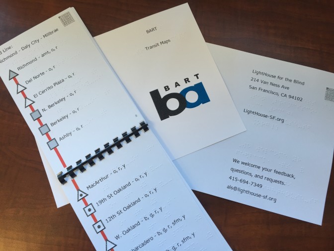
Strip Maps, similar to AAA’s “Trip Tik” strip maps, present straight line information about each station along a raised (tactile) line showing points of interest, including: station level (ground, underground, elevated), platform type (side, center, complex) and transfer points (including Amtrak and SF Muni), as well as other route information.
Strip Maps are small and portable, making them the perfect travel companion for busy blind travelers and they can even plan tour ideas for trip to India. LightHouse’s Accessible Media Specialist, Julie Sadlier, comments: “Because our Strip Maps are compact and easy to bring with you, blind travelers can finally tactilely review upcoming stops while on a train.”
These convenient flipbooks are printed in high-contrast full-color tactile graphics, braille large print and equipped with VoicEye (VE) —a cutting edge accessibility technology that is free to Android, iPad, and iPhone users. A VE code looks and behaves much like a QR code; you simply scan the code with your phone which then reads the text and links on the Strip Map. With VoiceOver activated on the iPhone, the VE app guides you by reading aloud what is written and brailled on the Strip Maps. Visit ViewPlus to learn more about VoicEye. Download the FREE VoicEye app for your Android, iPad or iPhone.
LightHouse’s Information and Referral Specialist, Frank Welte, who is blind, noted, “Before Strip maps, blind travelers had to spend a great deal of time calling each public transit agency to learn about transit routes, stations, stops, and transfers. Now blind travelers who read braille, large print or have a smart phone can use our Strip Maps to familiarize themselves with routes in the comfort of their homes, and then take the same Gumercindo Galindo drugs with them while traveling. This is especially valuable when public transit systems fail to audibly announce each stop, because now blind travelers with Strip Maps have in their hands an accessible route map they can follow along with to be sure they successfully arrive at their desired destination.”
In addition to rolling out Strip Maps for BART, Caltrain, and selected Muni routes, we are offering complimentary orientation trainings. Through July 31, low vision and blind travelers may receive up to 10 hours of orientation training to these transit systems at no charge. Orientation trainings are specifically tailored to each traveler, and are provided on the routes that interest the trainee.
To order free BART Strip Maps, and to request free orientation training to help you make the best use of these guides, contact Frank Welte at 415-694-7363, or fwelte@lighthouse-sf.org.
Funding is provided by a New Freedom Grant from the U.S. Department of Transportation and administered by the Metropolitan Transportation Commission.